AGTEGRA COOPERATIVE LAUNCHES A NEW UAV JOURNEY
Jun 12, 2020
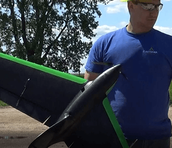
Unmanned Aerial Vehicles (UAV) continue to evolve in the world of agriculture and Agtegra Cooperative is here for it. Evan Howell, Ag Technology Lead for Agtegra recently trained with industry-leading organization Sentera on the operation of a highly developed UAV system. This system is capable of collecting images on up to 600 acres per hour with very precise resolution of data layers like crop health, whole field stand counts, weed distribution maps and yield estimation maps to list a few.
Operated 100% by computer, the PHX fixed wing UAV will allow Agtegra Cooperative to offer a new level of service to our Patrons. Director of Ag Technology Services, Brent Wiesenburger, more specifically notes that Agtegra will “be able to leverage the fixed wing UAV this growing season by measuring plant stands, equipment malfunction mapping and most importantly, evaluating the health of the growing crop. This will allow us to develop zone tissue sampling missions that will be used to make decisions for an in season nutrient application.” The benefit of the UAV to take these images is that you do not have to rely on satellite imagery that may not have quality images available when needed.
If optimizing the efficiency of your field scouting activities or targeting issues based on whole field data sounds like the right move for your operation, please contact a member of our Ag Technology team. Together, we can collect precise insights to what’s happening in your field and take action to protect and even enhance your yield objectives.